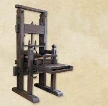
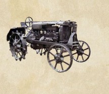
One of the great technical achievements that revolutionized the idea of time and space, opening a new era in the history of communication, is telegraphy. It is based on the transmission of electrical signals through a cable over long distances, allowing people to communicate instantly. The telegraph spread very quickly and a network of wires stretched around the world.
In 1837, the American painter and physicist Samuel Morse invented the first electromagnetic device for telegraphy, patented in 1840. To send messages by wire, Morse developed in 1838 a simple code of dots and dashes, which represented the letters of the alphabet, known as "Morse code ".
Both Morse code and the telegraph machine were improved over time, with the telegraph becoming the most widespread system of communication and information transmission for more than a century, until the advent of the Internet. The telegraph system consisted of a series of stations repeaters along the transmission line route. Each station had an operator who received and transmitted messages by telegraph. The Morse machine transmitted about 25 words per minute, which were recorded in code on a paper tape. The operator in charge of transmitting the message would decode it and write it on paper using a special typewriter.
In Bessarabia, the telegraph entered in 1860: on April 8, the Bender telegraph station began its activity, and on April 24, the one in Chisinau, following the construction of the first Odesa-Chisinau-Leova telegraph line. Currently, telegraph services have been discontinued. The only ones who still use coded communication are radio amateurs.
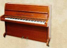
The Morse telegraph machine shown comes from the Osinoostrovsky electrotechnical plant, Soviet Union, and dates back to 1934. The exhibit was restored by Mihail Culașco.
Stanislav Țerna, Thomas Saile, Maciej Dębiec, Martin Posselt
Geophysical prospections and archaeological investigations of Late Neolithic - Early Copper Age sites from the Republic of Moldova (2014-2015)
Tyragetia, serie nouă, vol. X [XXV], nr. 1, Arheologie. Istorie Antică
Keywords: Republic of Moldova, Neolithic, Copper Age, LBK, Precucuteni - Tripolie A, architecture, geophysics.
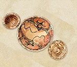
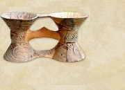
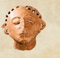
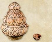
Abstract: Between 2014-2015, a joint Moldavian-German expedition undertook surface investigations, geophysical prospections and small-scale excavations on several LBK sites from the Republic of Moldova. This fieldwork allowed us to obtain unique data on the internal organization of Neolithic sites from the Prut-Dniester interfluve. The geomagnetic scans led to the identification of long houses, typical for the LBK from Central and Western Eu- rope. Some of these complexes have been checked by small test-trenches. The geophysical plots also included some Copper Age structures overlapping the LBK ones. Thus, we have been able to obtain the first complete geophysical plan of a Precucuteni settlement from the territory of Moldova. The analysis of the data obtained from the field led to a reconsideration of some older conceptions regarding the architecture and internal organization of LBK settlements from the North-Western Black Sea region.
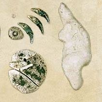
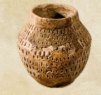
List of illustrations: Fig. 1. Localization of investigated sites on the general map of Neolithic and Early Copper Age settlements from the forest-steppe zone of the Prut-Dniester interfluve (Republic of Moldova). Map legend: black circles - LBK settlements; white circles - Precucuteni settlements; light-grey squares - Criș settlements; dark-grey squares - Bug-Dniester settlements. 1 - Bilicenii Vechi I; 2 - Sîngerei XIX; 3 - Chișcăreni XIV; 4 - Iezărenii Vechi VII; 5 - Iezărenii Vechi VIII; 6 - Sîngerei XIII; 7 - Nicolaevca V; 8 - Bumbăta III; 9 - Găureni I; 10 - Florești I. Fig. 2. Sîngerei XIX. Scanned area. Fig. 3. Sîngerei XIX. Geophysical plot. Fig. 4. Sîngerei XIX. Distribution of surface finds. Fig. 5. Sîngerei XIX. 1-34 - pottery. Fig. 6. Sîngerei XIX. 1-38- pottery. Fig. 7. Sîngerei XIX. 1-11 - pottery. Fig. 8. Sîngerei XIX. 1-17 - small finds. Fig. 9. Small finds from Iezărenii Vechi VII (1), Iezărenii Vechi VIII (2), Bilicenii Vechi I (3-4, 6) and Florești I (5) settlements. Fig. 10. Chișcăreni XIV. Scanned area and geophysical plot. Fig. 11. Chișcăreni XIV. Distribution of surface finds. Fig. 12. Chișcăreni XIV. 1-38 - pottery. Fig. 13. Chișcăreni XIV. 1-16 - pottery; 17-24 - small finds. Fig. 14. Nicolaevca V. Geophysical plot and its interpretation. Fig. 15. Nicolaevca V. Distribution of surface finds. Fig. 16. Nicolaevca V. 1-12 - pottery; 13-18 - small finds. Fig. 17. Bumbăta III. Geophysical plot and its interpretation. Fig. 18. Bumbăta III. Test-trench. Fig. 19. Bumbăta III. Finds. Fig. 20. Găureni I. Geophysical plot and its interpretation. Fig. 21. Găureni I. Test-trench 1. Fig. 22. Găureni I. Test-trench 2. Fig. 23. Găureni I. Outlines of archaeological features from test-trenches and the interpretation of the geophysical plot. Fig. 24. Găureni I. Finds. Fig. 25. Găureni I. Finds. Fig. 26. Găureni I. Finds.
Stanislav Țerna
Late Tripolian settlement near the village of Volovița (Soroca District, Republic of Moldova)
Tyragetia, serie nouă, vol. VIII [XXIII], nr. 1, Arheologie. Istorie Antică
One of the great technical achievements that revolutionized the idea of time and space, opening a new era in the history of communication, is telegraphy. It is based on the transmission of electrical signals through a cable over long distances, allowing people to communicate instantly...
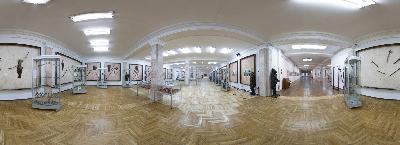
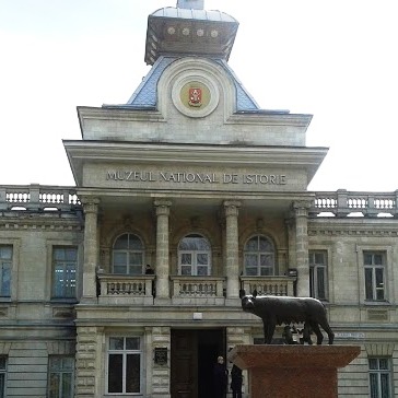
The National Museum of History of Moldova takes place among the most significant museum institutions of the Republic of Moldova, in terms of both its collection and scientific reputation.
The National Museum of History of Moldova takes place among the most significant museum institutions of the Republic of Moldova, in terms of both its collection and scientific reputation.
The National Museum of History of Moldova takes place among the most significant museum institutions of the Republic of Moldova, in terms of both its collection and scientific reputation.


, Tyragetia, serie nouă, vol. X [XXV], nr. 1, Arheologie. Istorie Antică")


