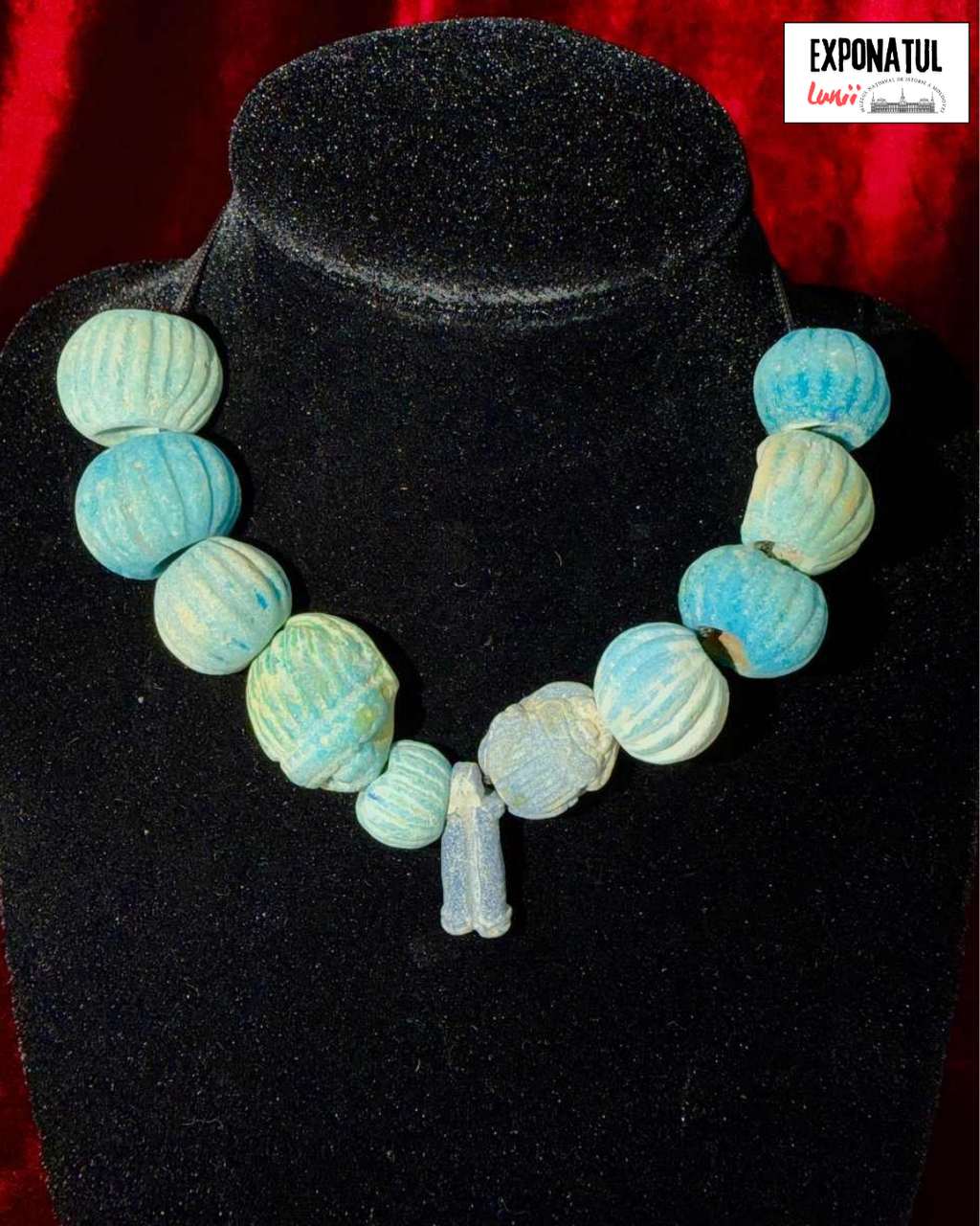
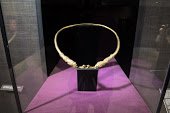
The exhibited necklace of beads originates from Funerary Complex No. 6 of Kurgan No. 4, excavated in 1982 by Dr. Habil. Eugen SAVA near the town of Taraclia. The beads were found in the chest area of the deceased, indicating that they had been worn as a necklace and had remained in their original position within the funerary assemblage. The necklace consists of 11 elements made entirely of Egyptian faience. Eight of the beads are spherical and decorated with vertical incisions forming between 14 and 21 raised ribs. Their diameters range from 13 to 20 mm. Two additional elements are scarab representations measuring 23.5 × 19.5 mm, while the final component is a flattened cylindrical pendant bead featuring a central vertical groove and measuring 22 × 9 mm. The objects range in color from light blue to dark blue and violet hues, reflecting the natural deterioration and glaze variations characteristic of Egyptian faience. Egyptian faience is an artificial quartz-based material coated with an alkaline glaze, typically blue or blue-green in color. It was widely used in Ancient Egypt and later spread throughout the Mediterranean and Pontic regions through trade networks. During the first centuries AD, such objects served as important indicators of cultural and economic contacts between the Mediterranean world and the communities of the North Pontic region. Owing to its typological, technological, and symbolic characteristics, the Taraclia necklace is an exceptionally valuable artifact for the study of intercultural relations, the circulation of prestige goods, and the funerary practices of the Sarmatian communities during the first centuries AD (1st-2nd centuries AD).
Tyragetia, serie nouă, vol. IV [XIX], nr. 1, Arheologie. Istorie Antică
The citadel is situated 600-800 m east of Mereșeuca village, Mereșeuca commune, Ocnița district, on a high, isolated hill, on the right bank of the Driver river. The local inhabitants call this headland „Cetățuie.” On the west side, the hill has the aspect of a narrow isthmus, crossed transversally by a flattened earth rampart. The isthmus becomes wider to the east of the wall, forming an ascending slope. One isthmus slope had been scarped at around 100 m away from the wall. Starting with the scarp level a semi-circular wall appears headed towards the south and north-east of the hill. One of the wall extremities ends at the northern steep edge of the hill, while another was probably connected to the scarp. The internal defensive line, repeating the shape of the anterior one, lies at the distance of 40-50 m from the wall and forms a central circular platform with a diameter of 100 m. The fortified surface of the citadel is about 2 ha.
The site was discovered in 1949 by T.S. Passek. The research uncovered four Eneolithic horizons and layers belonging to cultures Černoles, Sântana de Mureș-Černjachov and to the old Russian culture. The wall and ditch from the older cultural deposits had been sectioned in 1984. The ditch intersected the cultural layers going down into the sterile soil to the depth of 3.3-3.5 m. The ditch has a width of 0.8-1.0 m at the bottom and up to 5 m in the upper part.
In the outer part of the wall, as well as in the ditch’s channel, under the black-earth layer, a clay layer was attested provoked by downward erosion from the top hill where it initially lay at the base of the wooden wall built on the top rampart. The wall was probably made of a hull of beams, supported by pillars arranged vertically in pairs. The wall thickness reached around 2 m. The inferior part of the hull, which formed the wall, was filed up with earth, and the upper part formed chambers called strelnițe. Living and household structures built of beams were found in the inferior part of the rampart. It had around 8 m width at the base and 3 m heigh and rose around 6 m above ground together with the wall.
The ceramic and amphorae material discovered during the investigations allows us to dates the citadel to the 12th- 13th centuries. It was deserted and burnt probably by order of Tatar-Mongols at the middle of the 13th century. The closest analogies for Mereșeuca-Cetățuie fortification can be found at Lencăuți (fortress) and at Lomacinți, in northern Bucovina.
It appears that the fortress from Mereșeuca represents the southernmost outpost, an observation citadel of Halici from the right bank of Dniester. We can assume, as a hypothesis, that this citadel corresponds with the town Kucelmin from older Russian chronicles.
List of illustrations:
Fig. 1. Mereșeuca-Cetățuie: 1 - placement of citadel Mereșeuca-Cetățue on the map of Republic of Moldova; 2 – visual plan of fortress (1 - excavations from 1980, 2 - section through the wall and ditch); 3 - placement of the fortress on the topographic map; 4 - fortress Mereșeuca-Cetățuie, view from west. Fig. 2. Mereșeuca-Cetățue. Plan and profile of section through the wall and defensive ditch: 1 - south-east profile; 2 - north-west profile; 3 - agglomeration of stones and remains of grinders, in plan; 4 - plan of section bottom. Fig. 3. Mereșeuca-Cetățuie: 1-4 - Cucuteni-Tripolie ceramics; 5-7 - pieces from Bronze Age. Fig. 4. Mereșeuca-Cetățuie: 1-11 - ceramics from the 12th-13th centuries. Fig. 5. Mereșeuca-Cetățuie: 1-5, 7, 9 - ceramics from the 12th-13th centuries; 6, 8 - amphorae fragments from the 12th-13th centuries.
Иван Власенко
The results of archaeological exploration in central and northern regions of the Republic of Moldova
Tyragetia, serie nouă, vol. VI [XXI], nr. 1, Arheologie. Istorie Antică
Иван Власенко, Татьяна Щербакова
Ekaterinovka – single-layer settlement of the Sântana de Mureș-Chernyakhov culture
Tyragetia, serie nouă, vol. IX [XXIV], nr. 1, Arheologie. Istorie Antică Chișinău, 2015
Alexandru Levinschi, Ivan Vlasenco
The Getae burial with cremation at the medieval settlement of Poiana I
Tyragetia, serie nouă, vol. VII [XXII], nr. 1, Arheologie. Istorie Antică
Иван Власенко, Вячеслав М. Бикбаев
An medieval grave near the village Hîrtopul Mare
Tyragetia, serie nouă, vol. III [XVIII], nr. 1, Arheologie. Istorie Antică
Иван Власенко
Hallstatt cultural-chronological horizons of multilevel settlement Ivancea II
Tyragetia, serie nouă, vol. I [XVI], nr. 1, Arheologie. Istorie Antică Chișinău, 2007
The exhibited necklace of beads originates from Funerary Complex No. 6 of Kurgan No. 4, excavated in 1982 by Dr. Habil. Eugen SAVA near the town of Taraclia. The beads were found in the chest area of the deceased, indicating that they had been worn as a necklace and had remained in their original position within the funerary assemblage...
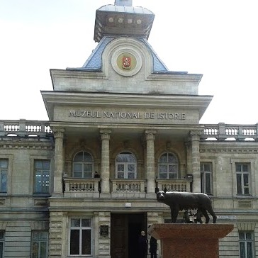
The National Museum of History of Moldova takes place among the most significant museum institutions of the Republic of Moldova, in terms of both its collection and scientific reputation.
The National Museum of History of Moldova takes place among the most significant museum institutions of the Republic of Moldova, in terms of both its collection and scientific reputation.
The National Museum of History of Moldova takes place among the most significant museum institutions of the Republic of Moldova, in terms of both its collection and scientific reputation.


 31 August 1989 St., 121 A, MD 2012, Chisinau, Republic of Moldova