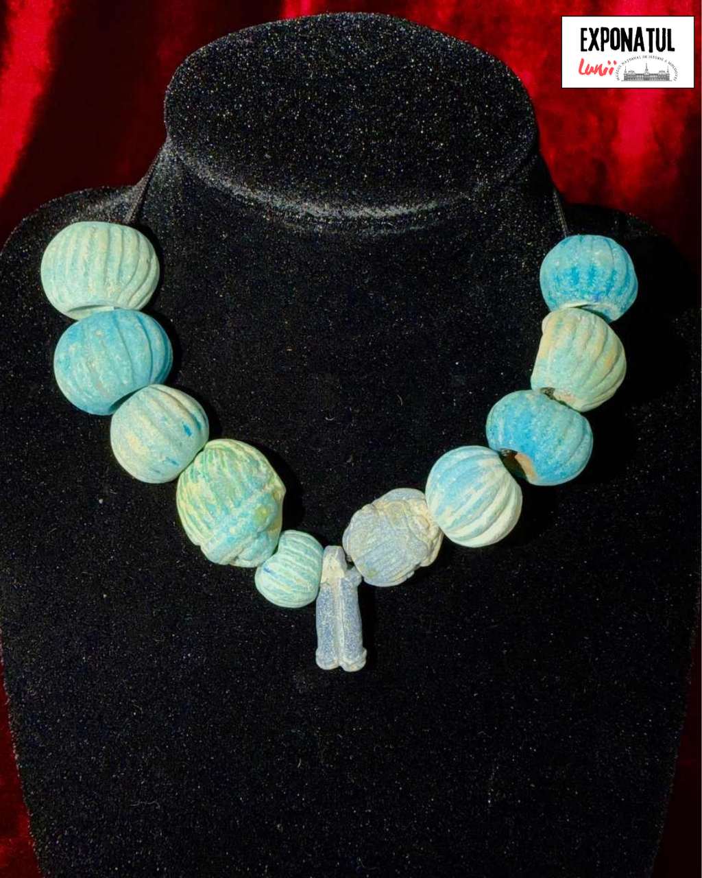
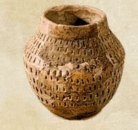
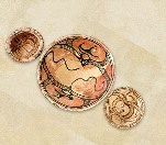
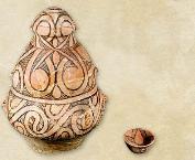
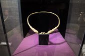
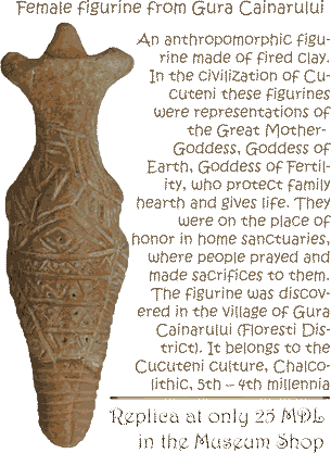
The exhibited necklace of beads originates from Funerary Complex No. 6 of Kurgan No. 4, excavated in 1982 by Dr. Habil. Eugen SAVA near the town of Taraclia. The beads were found in the chest area of the deceased, indicating that they had been worn as a necklace and had remained in their original position within the funerary assemblage. The necklace consists of 11 elements made entirely of Egyptian faience. Eight of the beads are spherical and decorated with vertical incisions forming between 14 and 21 raised ribs. Their diameters range from 13 to 20 mm. Two additional elements are scarab representations measuring 23.5 × 19.5 mm, while the final component is a flattened cylindrical pendant bead featuring a central vertical groove and measuring 22 × 9 mm. The objects range in color from light blue to dark blue and violet hues, reflecting the natural deterioration and glaze variations characteristic of Egyptian faience. Egyptian faience is an artificial quartz-based material coated with an alkaline glaze, typically blue or blue-green in color. It was widely used in Ancient Egypt and later spread throughout the Mediterranean and Pontic regions through trade networks. During the first centuries AD, such objects served as important indicators of cultural and economic contacts between the Mediterranean world and the communities of the North Pontic region. Owing to its typological, technological, and symbolic characteristics, the Taraclia necklace is an exceptionally valuable artifact for the study of intercultural relations, the circulation of prestige goods, and the funerary practices of the Sarmatian communities during the first centuries AD (1st-2nd centuries AD).
Geospatial and archaeological research in the micro-zone of Horodiște-Tipova
Tyragetia, serie nouă, vol. VIII [XXIII], nr. 1, Arheologie. Istorie Antică
From the right bank of the Dniester, north of the village of Țipova (Rezina District) begins a deep gorge with steep slopes. Near the village of Horodiște the gorge divides, forming a network of canyons which, in turn, outline a series of headlands.
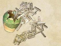
As a result of study of orthophotoplans and archaeological reconnaissance in the micro-zone there was discovered an "agglomeration" of sites, consisting of six fortifi cations (Horodiște „La Cot", Horodiște „La Șanț", Horodiște II, Buciușca II, Buciușca III, Țipova III ) and two unfortifi ed settlements (fig. 2).
In order to investigate the defense system and to determine the period of its functioning at Horodiște „La Cot" and Horodiște „La Șanț" an archeological research was carried out (fi g. 3-7). As a result, it was found that these fortifi ed settlements were surrounded by "walls" consisting of two wooden facings with a fi lling of earth and stone.
The archaeological materials recovered from the filling of the "walls" indicate that the fortifi cation of Horodiște „La Şanț" functioned during the early Hallstatt (Cozia-Saharna culture), and one of Horodiște „La Cot" - in the 4th - 3rd centuries BC (fi g. 8-12).
Based on the compact arrangement of fortifi cations and unfortifi ed settlements in the micro-zone of Horodiște-Tipova, it can be assumed the existence of some formation in this space, the "administrative center" of which was the fortress of Horodiște "La Cot". The period of its existence is still not clear. But if we take into account that most of the fortified and unfortifi ed settlements in the Middle Dniester region functioned since the early Iron Age, it can be assumed that the community of the Horodiște-Tipova area settled down here around that time. However, it reaches its peak of development in the 4th - 3rd centuries BC, as well as neighboring communities around Saharna.
List of illustrations:
Fig. 1. 1 - Location of the Horodiște-Țipova micro-region; 2 - digital elevation map of the micro-region. Fig. 2. Orthophotomap of the Horodiște-Țipova micro-region (fortifi ed settlements: 1 - Horodiște „La Cot"; 2 - Horodiște „La Şanț", 3 - Horodiște II; 4 - Buciușca III; 5 - Ţipova III; 6 - Buciușca II; unfortifi ed settlements: 7 - Buciușca IV; 8 - Buciușca V) (by Google Earth). Fig. 3. Horodiște „La Cot". Section no. 1. Ruins of a defensive structure on the south side: 1 - plan and profi le of the section; 2 - vertical stratigraphic profi le of the debris of the wall; 3 - fragments of charred wood. Fig. 4. Horodiște „La Cot": 1 - view of the headland from the northeast; 2, 3 - orthophotomaps tracing anomalies of the defensive line on the northern, eastern and southern sides (by geoportal.md and Google Earth); 4, 5 - remains of the defensive system on the east side today; 6 - view of the headland from the southwest indicating the rampart „C"; 7, 8 - orthophotomaps indicating the defensive lines „A", „B" and „C" (by geoportal.md); 9 - view of the defensive lines „B" and „C" from the northwest. Fig. 5. Horodiște „La Şanț": 1 - view of the headland from the south-west; 2 - orthophotomap of the site; 3, 4 - contour of abnormalities of the defensive lines. Fig. 6. Horodiște „La Şanț": 1 - view of the defensive line no. 1 from the south; 2 - view of the defensive line no. 3 from the south. Fig. 7. Horodiște „La Şanț". Defensive line no. 3. Section no. 1/2013: 1 - plan and profile of the section; 2 - stones from the debris of the "wall"; 3 - vertical profi le of the defensive structure. Fig. 8. Horodiște „La Şanț". The fi nds from the debris of the "wall". Fig. 9. Horodiște „La Şanț". Fragments of pottery of the Cozia-Saharna type from the cultural layer. Fig. 10. Horodiște „La Şanț". The fi nds from the cultural layer (1, 2 - iron; 3 - stone; 4, 5 - clay). Fig. 11. Horodiște „La Şanț". Fragments of vessels from the cultural layer. Fig. 12. Horodiște „La Şanț". Fragments of pots from the cultural layer. Fig. 13. Horodiște II: 1 - view of the headland from the east; 2 - orthophotomap (by geoportal.md). Fig. 14. Buciușca II: 1 - view of the headland from the west; 2 - orthophotomap (by geoportal.md). Fig. 15. Buciușca III: 1 - view of the headland from the south; 2 - orthophotomap (by geoportal.md); 3 -orthophotomap (by Google Earth); 4 - ruins of the defensive system. Fig. 16. Ţipova III. View of the headland from the northeast.
Aurel Zanoci, Mihail Băț
Archeological researches conducted in 2007 at the Thracian-Getian settlement of Saharna „La Şanț”
Tyragetia, serie nouă, vol. II [XVII], nr. 1, Arheologie. Istorie Antică
Ion Niculiță, Aurel Zanoci, Mihail Băț, Sergiu Matveev
Archaeological investigations at the site of Saharna Mare (2009-2011) (I)
Tyragetia, serie nouă, vol. VI [XXI], nr. 1, Arheologie. Istorie Antică
Mihail Băț
Early Iron Age settlement in Ţahnăuţi, Rezina District
Tyragetia, serie nouă, vol. XI [XXVI], nr. 1, Arheologie. Istorie Antică
Aurel Zanoci
Typology and evolution of gates and access into early hallstattian fortresses in Tisa-Dniester space
Tyragetia, serie nouă, vol. IX [XXIV], nr. 1, Arheologie. Istorie Antică Chișinău, 2015
Aurel Zanoci
Zur Typologie und Entwicklung der Befestigungsanlagen östlich der Karpatengebirge im 12./11.-3. Jh. v. Chr.
Tyragetia, serie nouă, vol. V [XX], nr. 1, Arheologie. Istorie Antică
The exhibited necklace of beads originates from Funerary Complex No. 6 of Kurgan No. 4, excavated in 1982 by Dr. Habil. Eugen SAVA near the town of Taraclia. The beads were found in the chest area of the deceased, indicating that they had been worn as a necklace and had remained in their original position within the funerary assemblage...
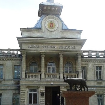
The National Museum of History of Moldova takes place among the most significant museum institutions of the Republic of Moldova, in terms of both its collection and scientific reputation.
The National Museum of History of Moldova takes place among the most significant museum institutions of the Republic of Moldova, in terms of both its collection and scientific reputation.
The National Museum of History of Moldova takes place among the most significant museum institutions of the Republic of Moldova, in terms of both its collection and scientific reputation.


 31 August 1989 St., 121 A, MD 2012, Chisinau, Republic of Moldova