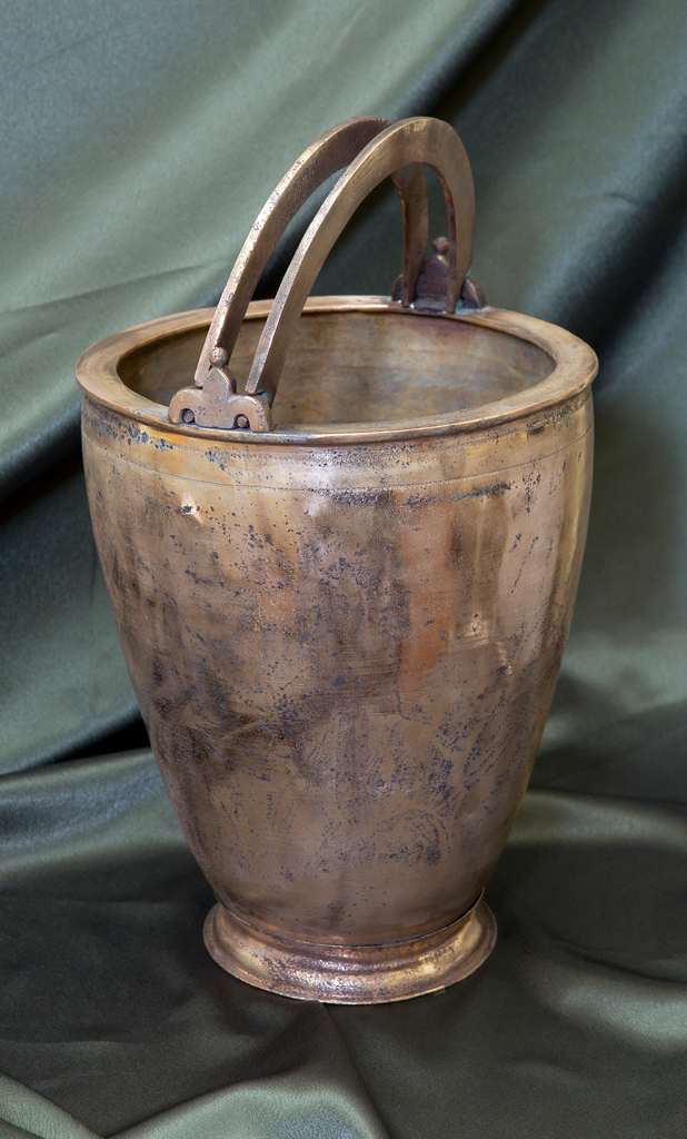
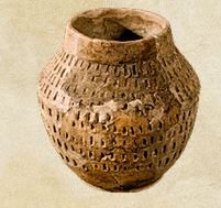
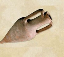
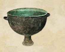
The Roman bronze situla comes from a collection of archaeological artifacts confiscated at customs and transferred to the holdings of the National Museum of History of Moldova in 2009. Its place of discovery remains unknown.
A situla (Latin for "bucket") is a metal vessel-usually made of bronze-shaped like a pail and equipped with two movable handles at the top, traditionally used for mixing wine with water. The handles are attached to the vessel via two decorated ears that are welded to the rim.
The body of the situla is truncated-conical in shape and features two decorative bands with small circular patterns formed by hammering, located just below the rim.
Its base is double-layered: the inner bottom is hemispherical and hammered, while the outer bottom is flat and lathe-made. The outer base is welded to the inner bottom, serving as the vessel's foot-support.
This object was crafted using a combination of casting, hammering, and partial lathe-finishing. Dimensions: Maximum height - 31.7 cm; Maximum diameter - 22.8 cm; Base diameter - 13.5 cm
Situlae of this type originated in the Roman Empire and were later adopted by various ancient peoples, including those from the northwestern Pontic region.
Ion Niculiță, Aurel Zanoci, Mihail Băț, Sergiu Matveev
Archaeological investigations at the site of Saharna Mare (2009-2011) (I)
Tyragetia, serie nouă, vol. VI [XXI], nr. 1, Arheologie. Istorie Antică
The Saharna Mare site (Rezina district) stands out among the monuments of the Middle Dniester area by its location and the degree of scrutiny. It is situated on a high rocky trapezoidal cape with an area of about 12 hectares, surrounded on three sides by deep canyons with inaccessible shores. Only from the south the cape is connected to the outside world.
Due to its strategic location, this area was inhabited as early as the end of the 2nd millennium B.C.
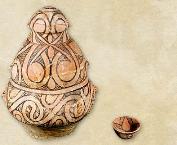
This monument drew the attention in the late 40s of the last century when there were conducted the first archaeological excavations (Smirnov, 1949, 93-96; Smirnov, 1949a, 189-202; Arnăut 2000, 93-104). Since 2001, an archaeological expedition of the Moldova State University conducts systematic research on the site. The results of studies conducted in 2001-2007 have been published in several articles and a monograph (Niculiță, Zanoci, Arnăut 2008a, 69-150). As a result of these investigations there were identified several cultural-chronological horizons: 1 - presented by complexes with incised pottery; 2 - relating to the Cozia-Saharna culture; 3 - Thracian-Getae (7th - 3rd centuries B.C.).
This article contains information about finds relating to the Cozia-Saharna culture, which were discovered as a result of the excavations of 2009-2011 carried out by five digs (13, 13A, 14, 15, 18) with the total area of 444 m2. Through the matching of orthophotomaps (fig. 4/1), the results of geomagnetic studies (fig. 3, 4/2), and archaeological research data (fig. 9/1) in the southeast of the cape there were found the remains of a “citadel” and the adjacent “fortified yard”. The “citadel” of a rounded shape (fig. 4/3), size 60×64 m (about 0,32 ha), was located on the southeastern out- skirts of the cape; it was reinforced on all sides by a moat and a wooden stone-earthen wall. The width of the moat varies from 4,2 to 6,0 m, depth – 0,7 to 1,6 m. The wall was built of two rows of wooden pillars dug vertically into the mainland loam. The space between rows was filled with stones and earth, thus forming a fortification of about 1,0-1,2 m in width.
The “citadel” had an adjacent semi-oval “yard” in the north-west side, with the dimensions of 55×78 m, which was also fortified by a moat (fig. 4/3). The width of the moat was 2-3 m, the depth – 1,0-1,4 m.
In the “citadel” there were investigated one ground construction (fig. 21), 37 household pits (fig. 23-32), and one religious construction? (fig. 33). There was also identified a sufficiently rich and varied inventory (fig. 36-45) that allowed to attribute the “citadel” and the adjacent “yard” to the Cozia-Saharna culture.
Most likely, these fortifications were designed to shelter residents of the Saharna “Dealul Mănăstirii” settlement, which was in close proximity. In addition, the “citadel” could serve as a socio-political and religious center for the Early Hallstatt population of the Saharna region (fig. 46).
List of illustrations: Fig. 1. Geographical and topographical location of the Saharna Mare site. Fig. 2. Saharna Mare. Topographical plan. Fig. 3. Saharna Mare. Topographical plan and magnetometric map. Fig. 4. Saharna Mare. Location of the Early Hallstatt “ citadel “ and the “adjacent yard”: 1 - orthophotomap (source: Google earth); 2 - magnetometric map; 3 - plan-scheme. Fig. 5. Saharna Mare. Plans and profiles of excavations 13/2009 and 14/2010. Fig. 6. Saharna Mare. The plan and profile of the excavation 13А/2010. Fig. 7. Saharna Mare. The plan and profile of the excavation 15/2010-2011. Fig. 8. Saharna Mare. The plan and profile of the excavation 18/2011. Fig. 9. Saharna Mare. Remains of fortifications of the Hallstatt „citadel”. Fig. 10. Saharna Mare. Variant of reconstruction of a defensive wall of the Hallstatt „citadel”. Fig. 11. Saharna Mare. Findings from the remains of the defensive wall: 1 - clay stamp; 2 - zoomorphic figurine. Fig. 12. Saharna Mare. Pottery from the remains of the defensive wall. Fig. 13. Saharna Mare. Pottery found at the bottom of the defensive wall. Fig. 14. Saharna Mare. Pottery found in the layer under the base of the defensive wall. Fig. 15. Saharna Mare. Defensive moat of the Early Hallstatt „citadel”: 1 - south-western sector (Excavation 7/2003); 2 - north-western sector (Excavation 13/2009); 3 - north-eastern sector (Excavation 15/2010). Fig. 16. Saharna Mare. Photos of profiles of the Early Hallstatt “citadel” defensive moat: 1 - north-western sector (Excavation 13/2009); 2 - north-eastern sector (Excavation 15/2010). Fig. 17. Saharna Mare. Early Hallstatt material found in the filling of the defensive moat. Fig. 18. Saharna Mare. Defensive moat of the “adjacent yard”: 1 - south-western sector (Excavation 10/2006); 2 - north-eastern sector (Excavation 10/2006); 3 - northern sector (Excavation 18/2011). Fig. 19. Saharna Mare. Photos of the defensive moat of the “adjacent yard”: 1 - south-western sector (Excavation 10/2006); 2 - north-eastern sector (Excavation 10/2006); 3 - northern sector (Excavation 18/2011). Fig. 20. Saharna Mare. Early Hallstatt pottery from the filling of the “adjacent yard” moat. Fig. 21. Saharna Mare. Construction no. 3: 1 - plan and profile; 2 - remains of the construction (view from the east); 3 - vessel in situ. Fig. 22. Saharna Mare. Pottery from the construction no. 3. Fig. 23. Saharna Mare. 1 - Plan and profile of the pit no. 104; 2 - plan and profile of the pit no. 105; 3 - plans and profiles of the pits no. 106 and no. 107; 4-8 - inventory of the pit no. 104; 9, 10 - inventory of the pit no. 105; 11 - inventory of the pit no. 106; 12-16 - inventory of the pit no. 107. Fig. 24. Saharna Mare. 1 - Plan and profile of the pit no. 108; 2 - plan and profile of the pit no. 109; 3 - plan and profile of the pit no. 110; 4-14 - inventory of the pit no. 108; 15-19 - inventory of the pit no. 109; 20-23 - inventory of the pit no. 110. Fig. 25. Saharna Mare. 1 - Plan and profile of the pit no. 111; 2 - plan and profile of the pit no. 112; 3 - plan and profile of the pit no. 113; 4-13 - inventory of the pit no. 111; 14, 15 - inventory of the pit no. 112; 16-24 - inventory of the pit no. 113. Fig. 26. Saharna Mare. 1 - Plan and profile of the pit no. 114; 2 - plan and profile of the pit no. 115; 3-14 - inventory of the pit no. 114; 15, 16 - inventory of the pit no. 115. Fig. 27. Saharna Mare. 1 - Plan and profile of the pit no. 116; 2 - plan and profile of the pit no. 117; 3 - plan and profile of the pit no. 118; 4 - plan and profile of the pit no. 119; 5 - inventory of the pit no. 116; 6, 7 - inventory of the pit no. 118; 8-23 - inventory of the pit no. 119. Fig. 28. Saharna Mare. 1 - Plan and profile of the pit no. 120; 2 - plan and profile of the pit no. 121; 3 - plan and profile of the pit no. 122; 4-8 - inventory of the pit no. 120; 9-15 - inventory of the pit no. 121; 16 - inventory of the pit no. 122. Fig. 29. Saharna Mare. 1 - Plans and profiles of the pits no. 123, no. 124 and no. 138; 2 - plan and profile of the pit no. 125; 3-10 - inventory of the pit no. 123; 11 - inventory of the pit no. 124; 12-16 - inventory of the pit no. 125. Fig. 30. Saharna Mare. 1 - Plan and profile of the pit no. 126; 2-38 - inventory of the pit no. 126. Fig. 31. Saharna Mare. 1 - Plan and profile of the pit no. 127; 2 - plan and profile of the pit no. 128; 3 - plan and profile of the pit no. 129; 4 - inventory of the pit no. 127; 5 - inventory of the pit no. 128; 6-1 - inventory of the pit no. 129. Fig. 32. Saharna Mare. Pits without inventory, which belong to the Early Hallstatt period. Fig. 33. Saharna Mare. 1 - Plan and profile of the Accumulation no. 1; 1а - plan of the hearth no. 9; 2 - hearth no. 9; 3 - accumulation of stones, human bones, and pottery; 4 - general view of the Accumulation no. 1 and the hearth no. 9. Fig. 34. Saharna Mare. Archaeological findings from the Accumulation no. 1. Fig. 35. Saharna Mare. Fragments of pottery from the Accumulation no. 1. Fig. 36. Saharna Mare. Objects of the Early Hallstatt period (1 - iron; 2-8 - bone; 9-14 - stone; 15-27 - clay). Fig. 37. Saharna Mare. Fragments of bowls from the cultural layer. Fig. 38. Saharna Mare. Fragments of bowls from the cultural layer. Fig. 39. Saharna Mare Fragments of bowls from the cultural layer. Fig. 40. Saharna Mare. Fragments of bowls from the cultural layer. Fig. 41. Saharna Mare. Fragments of goblets from the cultural layer. Fig. 42. Saharna Mare. Fragments of pots from the cultural layer. Fig. 43. Saharna Mare. Fragments of pots from the cultural layer. Fig. 44. Saharna Mare. Fragments of pots from the cultural layer. Fig. 45. Saharna Mare. Fragments of pottery from the cultural layer. Fig. 46. Spreading of the sites in the Saharna region.
Sergiu Matveev
The beginnings of archaeology in MSSR
Tyragetia, serie nouă, vol. X [XXV], nr. 1, Arheologie. Istorie Antică
Sergiu Matveev
The reflection of the ethno-cultural processes from the 2nd-14th centuries between Prut and Nistru in the soviet ethno-folck studies
Tyragetia, serie nouă, vol. I [XVI], nr. 2, Istorie. Muzeologie Chișinău, 2007
Aurel Zanoci, Mihail Băț
Archeological researches conducted in 2006 at the Thracian-Getian settlement Saharna „La Şanț”
Tyragetia, serie nouă, vol. I [XVI], nr. 1, Arheologie. Istorie Antică Chișinău, 2007
Sergiu Matveev
Andrea Popa, Managementul integrat al patrimoniului mondial în România. Studiu de caz: Frontiera romană în Dacia. Siturile de epocă romană de la Breţcu, Comolău şi Boroşneu Mare. Sibiu: Astra Museum, 2023, 279 p. ISBN 978-606-733-361-9
Tyragetia, serie nouă, vol. XVIII [XXXIII], nr. 1, Arheologie. Istorie Antică
Aurel Zanoci
Typology and evolution of gates and access into early hallstattian fortresses in Tisa-Dniester space
Tyragetia, serie nouă, vol. IX [XXIV], nr. 1, Arheologie. Istorie Antică Chișinău, 2015
The Roman bronze situla comes from a collection of archaeological artifacts confiscated at customs and transferred to the holdings of the National Museum of History of Moldova in 2009. Its place of discovery remains unknown....
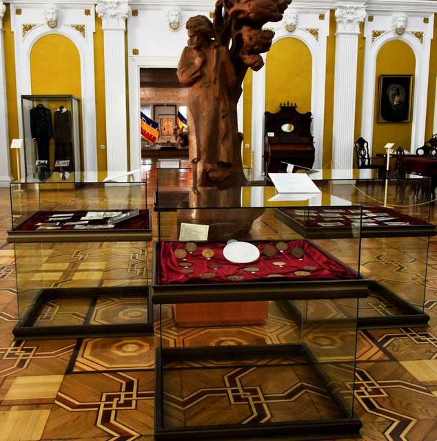
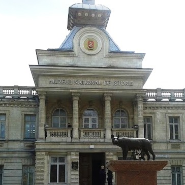
The National Museum of History of Moldova takes place among the most significant museum institutions of the Republic of Moldova, in terms of both its collection and scientific reputation.
The National Museum of History of Moldova takes place among the most significant museum institutions of the Republic of Moldova, in terms of both its collection and scientific reputation.
The National Museum of History of Moldova takes place among the most significant museum institutions of the Republic of Moldova, in terms of both its collection and scientific reputation.


 (I), Tyragetia, serie nouă, vol. VI [XXI], nr. 1, Arheologie. Istorie Antică")


