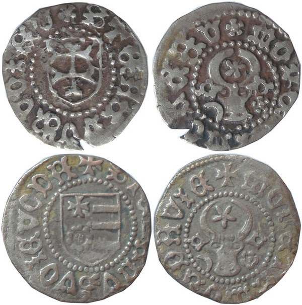
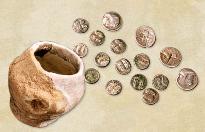
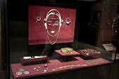
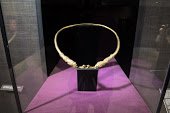
The great ruler Stephen the Great, outstanding army commander and diplomat, was also concerned during his life with the economic prosperity of the country, supporting the development of crafts, trade and fairs. During his reign, groși and half groși minted in the dinar system were issued, a monetary system introduced in Moldova during the last reign of Petru Aron (1455-1457).
The coins were minted from silver of superior title, those that reflect stability in the economic life of the country at that time. Their masterful execution at the Suceava mint is among the beautiful artistic achievements during the reign of Stephen the Great.
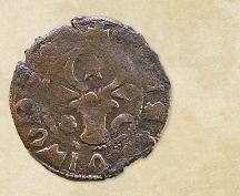
During his reign, two types of issues were minted, for the two denominations: groși and half groși.
Type I issues have a split shield on the obverse; in the first quarter appears a rose surmounted by a cross and three fascias, in the second quarter. For the epigraph issues (groși), the image is accompanied by the circular legend with the name of the issuer: + STEFANVS VOIEVODA. On the other side appears the bour's head with a star between the horns accompanied by the heraldic furniture - the rose and the contoured crescent, placed to the right and left of the bour's head; circular legend: MOLDAVIE COIN.
On type II coins in the shield on the obverse appears a patriarchal cross (double) and the legend STEFANVSVOIEVOD or abbreviated STEFANVSVOIE. On the reverse, as in type I, the bour's head with heraldic attributes is preserved: rose right/crescent left and crescent right/rose left. A star or rose appears between the ox's horns. The legend accompanying the face with the bour head is MONETAMOLDAVI or abbreviated MONETAMOLDA.
The dating of Stephen the Great's coins is still under discussion. According to one opinion, type I issues were minted between 1457-1476, and type II between 1480/1481-1505 (Octavian Iliescu), and another 1465/1467-1475/1476 for type I and 1476/1479-1497 for type II (Ernest Oberländer-Târnoveanu).
The coins in this showcase were discovered during the archaeological excavations at Orheiul Vechi (Trebujeni, Orhei district) in the 6th and 7th decades of the 20th century:
1. Type I money issues, groși, silver 2. Type II money issues, groși, silver 3. Type II coin issue, half groși, silver
Les etapes d’édification de la fortification de Horodca Mică
Tyragetia, serie nouă, vol. VII [XXII], nr. 1, Arheologie. Istorie Antică
La fortification Horodca Mică est située dans la zone centrale de l'espace pruto-dniesterien, aux environs des sources de la rivière Botna, et elle est devenue objet des recherches systématiques depuis 2006. Plusieurs des résultats obtenus depuis cette date on été publiés entre temps. On compte parmi ceux-ci une étude concernant les éléments défensifs de la forteresse, où l'on a mis en avant l'hypothèse d'une fortification par étapes, du promontoire, alternées avec des destructions périodiques. Au départ, on avait plus insisté sur la première phase d'édification du système défensif, en décrivant ses éléments constitutifs, les techniques utilisées dans le processus d'édification, mais aussi l'évolution de la fortification même, jusqu'au dévastateur incendie qui a écroulé la construction défensive.
Dans cet article on a repris le débat portant sur le système défensif. L'hypothèse sur laquelle on se fonde admet l'existence de trois autres phases de refortification du même espace, suite à la première destruction. Pour l'argumentaire de ce point de vue on s'est proposé de présenter dans un premier temps, le tableau des observations objectives, enregistrées sur le terrain, et dans un deuxième temps, partant de ces observations, offrir une explication de la vision que nous avons construit. Cette analyse porte y compris sur les modalités d'édification du système défensif dans chacune des phases identifiées, sur les techniques et matériaux utilisés, ainsi que des raisonnements concernant les repères chronologiques.
On est donc d'avis que dans ces phases ultérieures de fortification du promontoire, a été procédé de la même manière que dans la première : un fossé a été creusé (en réalité c'est l'ancien qui a été étendu en largeur), derrière a été montée une palissade complexe, en bois (sur le sommet même de la vague constituée suite à l'écroulement de la construction de la phase précédente), remplie avec de la terre excavée du fossé. Dans la situation crée, la berme utilisée dans la première phase d'édification du système défensif, n'y trouvait plus sa place. Ainsi, on estime que la délimitation du fossé proprement-dit, depuis l'intérieur, doit être fixée par rapport à la palissade. De cette manière, des barrières solides ont pu être créées, qui, dû à leurs dimensions impressionnantes, ont protégé à plusieurs reprises la population de ces espaces, dans les siècles V à III a. Chr.
Liste des figures:
Fig. 1. Horodca Mica. 1 - Localisation du site Horodca; 2 - schéma topographique avec l'emplacement des section stracés entre 2006-2011.
Fig. 2. Horodca Mică. Section nr. I: 1-4 - images de la période de recherche du système défensif.
Fig. 3. Horodca Mică. Section nr. I. Vue sur le profil de l'ouest avec la délimitation des diverses phases de construction. Fig. 4. Horodca Mică. Section nr. I. Profil de l'ouest.
Fig. 5. Horodca Mică. Section nr. I: 1 - plan et profil de l'ouest dans les carreaux A1-A15; 2 - plan et profil de l'ouest dans les carreaux A1-A9 (la double ligne marque les délimitations imaginaires).
Fig. 6. Horodca Mică. Section nr. I. Vestiges du fourneau aménagé dans les couches supérieures du groupe de len- tilles qui forme les restes écroulés de la construction de la 1ère phase d'édification.
Fig. 7. Horodca Mică. Section nr. I: 1 - plan et profil avec l'indication des délimitations imaginaires du niveau an- tique de marche et des fossés dans les diverses phases d'édification de la fortification (la ligne double); 2 - plan et profil avec la reconstruction.
Fig. 8. Horodca Mică. Section nr. I: 1 - vue sur le profil de l'ouest dans le carreau A5 avec la délimitation du com- plexe 103; 2 - vue sur le profil de l'ouest dans le carreau A4 avec la délimitation des complexes 104, 105 et 106.
Fig. 9. Horodca Mică. Section nr. I: 1 - la délimitation des lentilles de sol entre la 1ère et la 2ème phase d'écroulement de la fortification; 2 - vues sur le fossé nr. I.
Fig. 10. Horodca Mică. Section nr. I: 1 - plan et profil avec l'indication des délimitations imaginaires du niveau antique de marche, et des fossés dans les diverses phases d'édification de la fortification (la ligne double); 2 - plan et profil avec la reconstruction schématique de la fortification de la 3ème phase
Fig. 11. Horodca Mică. Section nr. I: 1 - plan et profil avec l'indication des délimitations imaginaires du niveau antique de marche et des fossés dans les diverses phases d'édification de la fortification (la ligne double); 2 - plan et profil avec la reconstruction schématique de la fortification de la 4ème phase.
Fig. 12. Horodca Mică. Section nr. I. Vues sur le fossé nr. 4.
Fig. 13. Horodca Mică. Section nr. I: 1, 2 - vue sur les fosses qui constituait les rangées de poteaux; 4 - fosse nr. 1; 3, 5 - fosse nr. 8; 6 - fosse nr. 8a.
Ion Tentiuc, Octavian Munteanu
The connections of the East Carpathian region with the world of the Vikings: new find of the chape of the scabbard of an early medieval sword in the territory of Moldova
Tyragetia, serie nouă, vol. XVI [XXXI], nr. 1, Arheologie. Istorie Antică, Chişinău, 2022
Jerzy Hatłas, Octavian Munteanu
Domed tombs of Thrace - 160 years of research
Tyragetia, serie nouă, vol. V [XX], nr. 1, Arheologie. Istorie Antică
Aurel Zanoci, Octavian Munteanu, Ion Tentiuc, Valeriu Bubulici
New archaeological discoveries of the Iron Age sites near the village of Mana, Orhei District
Tyragetia, serie nouă, vol. IX [XXIV], nr. 1, Arheologie. Istorie Antică Chișinău, 2015
Octavian Munteanu
Élements defensifs dans la fortification gete du Horodca Mare, districte Hâncești
Tyragetia, serie nouă, vol. IX [XXIV], nr. 1, Arheologie. Istorie Antică Chișinău, 2015
Octavian Munteanu, Vasile Iarmulschi
Pilot excavations at Horodca Mică fortification
Tyragetia, serie nouă, vol. I [XVI], nr. 1, Arheologie. Istorie Antică Chișinău, 2007
The great ruler Stephen the Great, outstanding army commander and diplomat, was also concerned during his life with the economic prosperity of the country, supporting the development of crafts, trade and fairs. During his reign, groși and half groși minted in the dinar system were issued, a monetary system introduced in Moldova during the last reign of Petru Aron (1455-1457)...
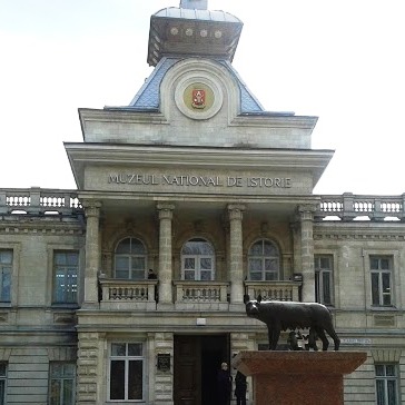
The National Museum of History of Moldova takes place among the most significant museum institutions of the Republic of Moldova, in terms of both its collection and scientific reputation.
The National Museum of History of Moldova takes place among the most significant museum institutions of the Republic of Moldova, in terms of both its collection and scientific reputation.
The National Museum of History of Moldova takes place among the most significant museum institutions of the Republic of Moldova, in terms of both its collection and scientific reputation.


